With a coastline that stretches nearly 2,500 kilometres up the east coast of Africa, Mozambique is the ideal destination for a beach holiday.

Finding your bearings...
Mozambique lies on the south east coast of Africa. It is renowned for its great sandy beaches, delicious fresh seafood and some of the best diving spots in the world.

From Maputo to Pemba
Most of Mozambique's major cities are located on the coastline, such as its vibrant capital Maputo. They are known for their interesting Portuguese architectural styles.

Come and discover diving paradise
From Whale Sharks and Mantas to Turtles and Dolphins the Bazaruto and Quirimbas dive sites offer some of the best preserved coral reefs on the planet.

An undiscovered wildlife paradise
Discover Africa's lost Eden's the Gorongossa and Niassa National Parks which abound with wildlife including large herds or Elephants and many Giant crocodiles.

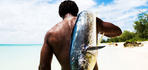
Choose your thrill - from big game fishing to dune surfing
Diving and swimming are not the only activities on offer in Mozambique - explore the coastline in a traditional dhow, or try deep sea fishing for Marlin.

A range of wonderful holiday accommodation
From beach resorts to quaint bungalows and affordable self-catering bungalows there is a range of accommodation available in Mozambique.